MAKE A MEME
View Large Image

| View Original: | 1846_-_1879_Colton_Map_of_New_York_City_^_Vicinity_(33_Miles_Around)_-_Geographicus_-_NYC33Miles-colton-1879.jpg (4000x4190) | |||
| Download: | Original | Medium | Small | Thumb |
| Courtesy of: | commons.wikimedia.org | More Like This | ||
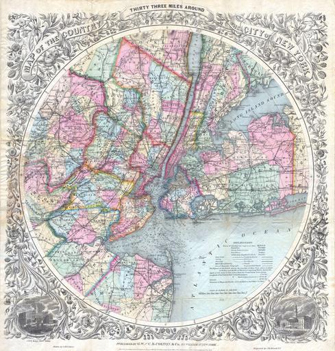
| Keywords: 1846 - 1879 Colton Map of New York City ^ Vicinity (33 Miles Around) - Geographicus - NYC33Miles-colton-1879.jpg This is the extremely rare 1879 edition of one of the most beautiful pocket maps of New York made in the 19th century Colton �s Thirty Three Miles Around the City of New York Covers New York City and vicinity as far south as Ocean County NY as far east as Suffolk County as far north as Rockland County and as far west as Somerset County Reveals the area in considerable detail with special attention to settlements tolls roads and railroads Documents innumerable areas of interest included the New Lots in Brooklyn and a very early Central Park New York Bay and Harbor offers numerous depth soundings taken from the 1858 U S Coast Survey of the region Surrounded by a splendid decorative border with engraved views depicting City Hall New York and City Hall Brooklyn This map was drawn and engraved by J M Atwood based upon J H Eddy �s 1811 map of the same name Colton �s success with this attractive map was such that it was issued in various editions for over 50 years Haskell notes eight different editions between 1846 and 1873 and Rumsey has a variant dated 1891 We have found no references to our 1879 variant in any major collection or reference work Folds into its original dark green linen binder Miniature map of the city in gilt stamped on the cover Dated 1870 under the title and at the base of the map the copyright reads Entered according to the Act of Congress in the Year of 1846 by J H Colton Co in the Clerk �s Office of the District Court of the Southern District of New York Published by Johnson Browning from their 172 William Str Office in New York City 1879 dated Size in 22 5 24 object history credit line accession number NYC33Miles-colton-1879 Hand Color Geographicus-source PD-old-100 Old maps of New York City 1879 1879 maps Maps by Joseph Hutchins Colton Round maps Maps in English New York City Hall Brooklyn Borough Hall | ||||