MAKE A MEME
View Large Image

| View Original: | The_Quarterly_journal_of_the_Geological_Society_of_London_(13206074283).jpg (1199x2069) | |||
| Download: | Original | Medium | Small | Thumb |
| Courtesy of: | commons.wikimedia.org | More Like This | ||
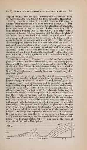
| Keywords: The Quarterly journal of the Geological Society of London (13206074283).jpg 1847 VICARY ON THE GEOLOGICAL STRUCTURE OF SINDE 341 <br> irregular coating of sand resting on the same yellow clay so often alluded <br> to Kotree is on the right bank of the Indus opposite to Hyderabad <br> Having taken in supplies I proceeded hence to Ukka-Nag a <br> spring of sweet water in the hills about seventeen miles N N W from <br> Kotree thirteen miles of this was over the plain through which the <br> Indus now finds its way to the sea I then came upon hills of <br> small elevation trending N N E and S S W The range here is <br> composed of isolated hills not exceeding 400 feet above the plain of <br> the Indus their apices level with nearly horizontal strata their <br> sides abrupt and precipitous the uppermost beds being in all re- <br> spects similar to the non-nummulitic rock No 6 The valleys or <br> intervening spaces between these hills have been much disturbed A <br> variegated clay abounding with gypsum is of common occurrence <br> but contains no fossils A brown rust-coloured rock is abundantly <br> distributed on the surface near this in the form of large rounded <br> boulders and the Kotree blacksmiths occasionally visiting this place <br> select the most promising specimens and transport them to Kotree <br> for the manufacture of iron <br> Hence in a northerly direction I proceeded to Buchera in the <br> plain of the Indus for about fifteen miles and the country passed <br> through held the same character to within half a mile of the base <br> of the hills here I found the conglomerate resting on a thin bed of <br> arenaceous rock which I could not identify and which reposed upon <br> No 7 The conglomerate eventually disappeared beneath the yellow <br> clay of the plain <br> Water was not to be had within the hills at this season of the <br> year ; I was therefore obliged to continue my journey as far as <br> Luckee through the plain of the Indus The Kotree range of hills <br> terminates nearly west of Majinda and is succeeded by another <br> range trending nearly north as far as Sehwan ; the water of this range <br> except at Rennie-kote is salt and unfit for use ; the hills attain con- <br> siderable elevation from 600 to 800 feet above the Indus towards <br> which their aspect is very precipitous ; they are the abode of the <br> true Ibex Between this range and the Indus there are numerous <br> low hillocks of aluminiferous clay from which the Sindees manufac- <br> ture alum I was unable to ascertain the exact relation of these clays <br> with respect to the beds entering into the formation of the more ele- <br> vated range The proper time to explore this place would be after <br> a fall of rain when water would be obtainable from ponds � Moved <br> on to Luckee which is about sixteen miles to the southward of <br> Sehwan The range here approaches the river and is of easy access <br> It is not so high here as further to the southward and becomes gra- <br> dually lower in a northerly direction towards Sehwan where it termi- <br> nates The following section will give some idea of the range of <br> mountain at the Luckee Hot Springs <br> Fig 2 <br> w <br> ladus <br> No 6 <br> Bed of stream <br> No 7 36933100 113687 51125 Page 341 Text v 3 http //www biodiversitylibrary org/page/36933100 1847 Geological Society of London Biodiversity Heritage Library The Quarterly journal of the Geological Society of London v 3 1847 Geology Periodicals Smithsonian Libraries bhl page 36933100 dc identifier http //biodiversitylibrary org/page/36933100 smithsonian libraries Information field Flickr posted date ISOdate 2014-03-17 Check categories 2015 August 26 CC-BY-2 0 BioDivLibrary https //flickr com/photos/61021753 N02/13206074283 2015-08-26 12 52 34 cc-by-2 0 PD-old-70-1923 The Quarterly journal of the Geological Society of London 1847 Photos uploaded from Flickr by Fæ using a script | ||||